
GeoEdge Land Surveyors undertook a land subdivision survey in the Dagoretti area of Nairobi County, involving the survey and preparation of information required to create clearly defined resultant parcels. The project involved cadastral survey work, field measurements, parcel definition and preparation of subdivision documentation. The subdivision plan also incorporated considerations relating to access and other land features identified during the survey process.
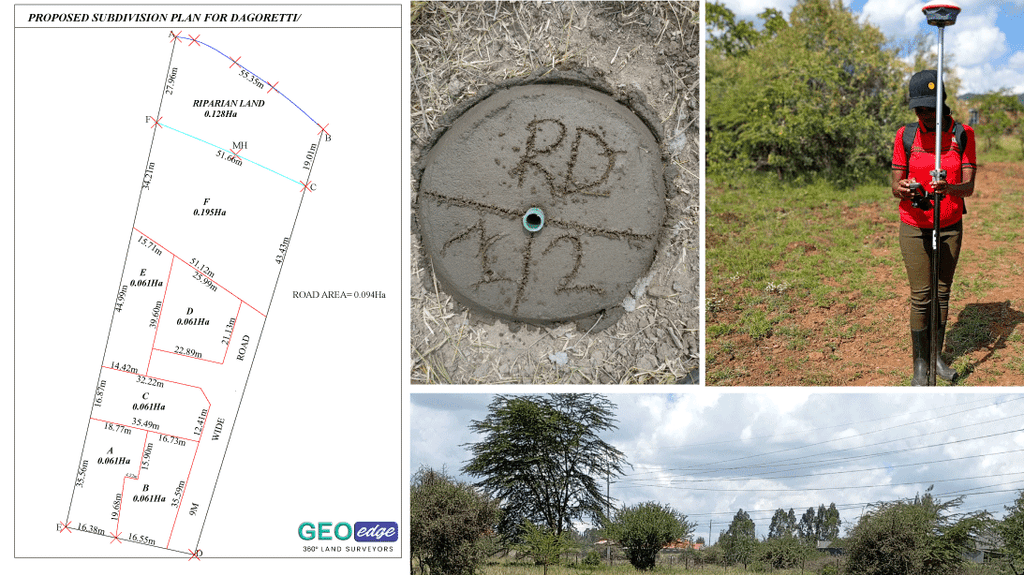
For client confidentiality, specific parcel numbers, coordinates, exact dimensions, measured areas and other sensitive cadastral information are not published in this case study.
1. Understanding the Survey Requirement
The assignment began with an assessment of the client’s subdivision requirements and the available property and survey information. The purpose of the survey was to translate the proposed subdivision into clearly defined parcels supported by appropriate survey measurements and documentation.
2. Review of Existing Survey Information
Before undertaking the fieldwork, the available survey information was reviewed to understand the existing property configuration and the information necessary for the proposed subdivision. This stage helps the survey team identify the relevant survey framework, existing boundaries and other features that need to be considered when preparing the subdivision.
3. Site Reconnaissance and Field Survey
GeoEdge’s survey team undertook fieldwork to obtain the measurements required for the subdivision. Field survey activities included establishing and checking relevant points on the property, taking measurements and collecting the spatial information required to prepare the subdivision survey. The fieldwork provides the connection between the proposed subdivision and the actual conditions on the ground.
4. Boundary and Parcel Definition
The survey information was processed to establish the proposed parcel configuration. The resultant parcels were defined using the measurements obtained during the field survey. This process is important because a subdivision is not simply the drawing of new lines on a plan; the proposed parcel arrangement must be supported by appropriate survey measurements.
5. Consideration of Access and Site Features
The subdivision plan illustrates provisions for access and identifies other site features that had to be considered in the subdivision arrangement. The plan includes an access road and identifies a riparian area. Such features are important during subdivision planning because the surveyor must consider the physical and spatial characteristics affecting the proposed parcel arrangement.
6. Preparation of the Subdivision Plan
Following the field survey and processing of the survey information, the subdivision arrangement was prepared and presented on the survey plan. The plan provides the spatial representation of the proposed resultant parcels together with relevant site features and access provisions. For public presentation, GeoEdge can display a photograph or appropriately cropped version of the plan while concealing sensitive cadastral information.
7. Technical Review and Verification
The prepared survey information was reviewed to ensure that the proposed subdivision was supported by the field measurements and that the parcel arrangement was properly represented. Technical checking is an important part of cadastral surveying because errors in measurements or parcel definition can affect subsequent land administration and property processes.
8. Survey Documentation
The project resulted in subdivision survey documentation showing the proposed parcel arrangement and relevant site information. The detailed cadastral information contained within the project documents remains confidential and is not reproduced publicly.
Project Outcome
The project provided the client with professional cadastral survey work supporting the subdivision of the property into clearly defined resultant parcels. The case demonstrates how a land subdivision involves more than measuring the property. It requires the surveyor to combine existing survey information, field measurements, parcel definition, technical processing and consideration of relevant site features to produce appropriate subdivision documentation.
What This Project Demonstrates
This project demonstrates GeoEdge Land Surveyors’ approach to:
- Land subdivision surveys
- Cadastral field measurements
- Boundary and parcel definition
- Preparation of subdivision survey information
- Consideration of access and site features
- Technical checking of survey information
- Professional handling of confidential property information
Client Confidentiality
GeoEdge Land Surveyors respects the confidentiality of client property and survey information. Accordingly, this case study intentionally excludes sensitive information such as exact coordinates, detailed cadastral identifiers, precise measurements, ownership information and other information that could unnecessarily disclose the particulars of the property.
The photographs and selected project documentation presented on this page are intended to demonstrate the nature and quality of the surveying work without compromising client confidentiality. Land Subdivision in Dagoretti.