
Remote sensing
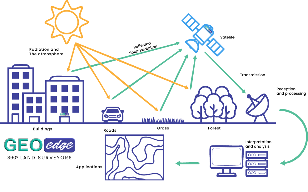
is the process of obtaining information about the Earth’s surface without physically being at every location being studied. It commonly uses sensors mounted on satellites, aircraft or drones to collect information about land, water, vegetation, built-up areas and other features.
Earth observation
is the broader process of using remotely sensed data and other observations to understand, monitor and analyse changes occurring on the Earth’s surface and in the environment. Satellite imagery is one of the most widely used sources of remote sensing data. Different satellites carry sensors that capture information in different parts of the electromagnetic spectrum. This allows us to identify and analyse features that may not be easily distinguished using ordinary photographs.
At GeoEdge Land Surveyors, we use remote sensing and Earth observation techniques to transform satellite and other remotely sensed data into useful spatial information for planning, monitoring, environmental assessment and decision-making.
1. Satellite Image Processing
Satellite imagery is not always ready to be used immediately after it is obtained. Raw or downloaded imagery may require several processing steps before it can be properly analysed.
Satellite image processing involves preparing imagery so that it is suitable for the specific purpose of a project.
Depending on the imagery and project requirements, processing may include: Image selection, Image downloading and preparation, Atmospheric correction, Radiometric correction, Geometric correction, Cloud and cloud-shadow masking, Image mosaicking, Image clipping, Resampling, Band combinations, Image enhancement, Spectral index calculation and Image classification
Different satellite missions provide different spatial, spectral and temporal characteristics. Therefore, the choice of imagery should be based on the objective of the project rather than simply using the most readily available image.
2. Land Use and Land Cover Mapping
Land cover refers to what physically covers the Earth’s surface while Land use refers more to how people use the land. Remote sensing provides an effective way of mapping these categories over large areas. As GeoEdge land surveyors, we use satellite imagery and image classification techniques to produce LULC maps showing the distribution of different land-cover or land-use classes.
These maps can support: Urban planning, Agricultural planning, Environmental management, Watershed management, Development planning, Natural-resource management, Infrastructure planning and Monitoring of land-use change. LULC mapping can also be repeated at different dates to understand how the landscape has changed.
LAND USE
3. Change Detection
Change detection involves comparing imagery or spatial datasets from different dates to identify changes that have occurred over time. Possible changes may include: Urban expansion, Deforestation, Vegetation recovery, Expansion of agricultural land, Reduction or expansion of water bodies, Wetland changes, Bare-land expansion, Changes in land cover and Infrastructure development. The exact methodology depends on the project, but a typical workflow may involve:
Image Selection → Pre-processing → Image Alignment → Classification/Index Calculation → Comparison → Change Analysis → Map Production
The output may include: Change maps, Change statistics, Time-series maps, Graphs, Area calculations and Interpretation reports. The objective is not simply to show that “something changed”, but to identify where the change occurred, what changed and, where the available evidence allows, the magnitude of the change.
4. Flood Mapping and Risk Assessment
Remote sensing provides an efficient way to observe and map flood-affected areas, particularly where access to the affected area is difficult.
Flood Mapping
Satellite imagery can be used to identify areas that have been inundated by water. Radar imagery can be particularly useful for flood mapping because radar sensors can acquire information through cloud cover and can operate during both day and night. Optical imagery can also provide valuable information where cloud-free observations are available.
Flood Mapping Workflow
Depending on the available data, our workflow may involve:
Pre-flood imagery → Post-flood imagery → Image processing → Water/inundation detection → Classification → Validation → Flood extent map
The final map can show: Flooded areas, Water extent, Nearby settlements, Roads, Buildings, Agricultural area, Infrastructure and Other potentially affected features
Flood Risk Assessment
Flood mapping tells us where flooding occurred or is occurring. Flood risk assessment goes further by examining the relationship between flooding and potentially affected people, property, infrastructure and environmental features.
A GIS-based assessment can combine: Flood extent, Elevation, Slope, Drainage, Land use, Roads, Buildings, Population, Infrastructure and Other relevant datasets These layers can then be analysed to identify areas with different levels of potential exposure or risk.
A remote sensing-based flood assessment is a technical analysis based on available spatial data and assumptions. It does not replace detailed hydrological, hydraulic or engineering flood modelling where such modelling is required.
5. Environmental Mapping
Environmental mapping uses remote sensing, GIS and other spatial information to understand the condition and distribution of environmental features.. It can be applied to: Vegetation, Forests, Wetlands, Water bodies, Agricultural landscapes Soil and bare land, Coastal environments, Protected areas and Degraded landscapes. Satellite imagery can provide repeated observations over large areas, making it useful for monitoring environmental conditions and identifying areas that require further investigation.
6. Satellite-Based Monitoring
One of the major advantages of Earth observation is the ability to monitor the same area repeatedly. Instead of conducting a completely new field survey every time information is required, satellite observations can provide a regular source of spatial information. Satellite-based monitoring can be applied to: Vegetation conditions, Agricultural areas, Urban growth, Water bodies, Wetlands, Forest cover, Land degradation, Flooding and Environmental change.
A project may require monitoring changes in vegetation over several years rather than producing a single map. Time-series satellite data can help reveal these patterns.
7. Image Classification
Image classification is the process of assigning pixels or groups of pixels in an image to defined classes based on their spectral or other characteristics. Classification can be broadly approached through methods such as:
Supervised Classification; Known training areas are provided for the classes of interest, and the algorithm uses these examples to classify the rest of the image.
Unsupervised Classification; The algorithm identifies groups of pixels with similar characteristics, which are then interpreted and assigned meaningful classes.
Accuracy Assessment; Classification should not end when the map has been produced. Where appropriate, we assess the classification using independent reference information and accuracy measures.
This helps determine how reliably the classified map represents the features on the ground.
8. Remote Sensing Analysis
Remote sensing analysis involves extracting meaningful information from remotely sensed data. This can range from simple visual interpretation to more advanced spectral and spatial analysis.
Depending on the project, analysis may involve; Spectral analysis, Vegetation indices, Water indices, Built-up indices, Image classification, Change detection, Time-series analysis, Multi-temporal analysis and Spatial statistics
Spectral Indices; Different features interact with electromagnetic energy in different ways. By combining selected spectral bands, we can calculate indices that help highlight particular characteristics.
9. Environmental and Natural-Resource Mapping
Remote sensing is particularly valuable for mapping natural resources over large and sometimes difficult-to-access areas. At GeoEdge, this may include mapping and monitoring: Forests, Vegetation, Wetlands, Water bodies, Agricultural areas, Grasslands, Bare land, Degraded areas and Other natural-resource features.
Such information can support: Environmental planning, Conservation, Natural-resource management, Agricultural planning, Watershed management, Land-use planning and Environmental monitoring. Remote sensing does not replace field observations, but it can provide a broader spatial picture and help identify areas where detailed field investigation may be required.
Our Approach to Remote Sensing and Earth Observation
At GeoEdge Land Surveyors, we do not treat satellite imagery as simply a background image for a map. Our approach is to identify the question that needs to be answered and then select the appropriate imagery, processing techniques and analytical methods.
1. Understand the Objective; Every project starts with a clear understanding of what the client wants to know and this determines the methodology.
2. Define the Area of Interest; We establish the geographical extent of the project.Clearly defining the area ensures that the appropriate imagery and supporting datasets are used.
3. Select Appropriate Satellite Data; Not all satellite imagery is suitable for every project.Depending on the project, we may work with imagery from platforms such as Sentinel, Landsat and other suitable Earth observation sources.
4. Image Pre-processing; Before analysis, the imagery is prepared to improve its suitability for the project.The objective is to produce imagery that is appropriate for the intended analysis.
5. Image Analysis; We then apply the appropriate analytical technique.We select the method based on the characteristics of the data and the question being investigated.
6. Integrate Remote Sensing with GIS; Remote sensing becomes even more useful when combined with GIS.This allows us to move from simply identifying an environmental phenomenon to understanding what may be affected by it.
7. Validate the Results; Where appropriate, we compare remote sensing results with available reference information. Validation helps us understand the reliability and limitations of the results.We believe that remote sensing analysis should communicate not only the result but also the level of confidence and limitations of the available data.
8. Analyse and Interpret the Results; We translate the processed information into outputs that the client can understand and use.Where appropriate, we explain the findings in straightforward language rather than leaving the client with technical satellite imagery alone.
9. Quality Control and Final Delivery; Before delivery, we check:Image processing, Classification, Spatial alignment, Coordinate reference system, Attribute information, Map layout, Accuracy assessment, Data completeness and the Final outputs.We then provide the agreed deliverables in formats appropriate for the client’s intended use.
Combining Remote Sensing, GIS and Surveying
At GeoEdge, we see remote sensing, GIS and land surveying as complementary technologies.
Each provides a different type of information.
Land Surveying; Provides detailed information about specific locations, boundaries, elevations and physical features on the ground.
Remote Sensing; Provides broad-area observations of the Earth’s surface from satellites, aircraft or other sensors.
GIS; Provides the environment for organising, integrating, analysing and visualising these different sources of spatial information.
Together, they can provide a more comprehensive understanding of a site or landscape.
Why Choose GeoEdge for Remote Sensing and Earth Observation?
At GeoEdge Land Surveyors, our objective is not simply to produce satellite imagery or attractive maps. We aim to turn Earth observation data into reliable, understandable and useful spatial information.
Our work combines:
Appropriate Data + Sound Processing + Spatial Analysis + GIS + Validation + Professional Interpretation
We understand that different projects require different approaches. A flood assessment does not require the same workflow as a land-use mapping project, and environmental monitoring does not necessarily require the same data as urban growth analysis.
We therefore develop our methodology around the project objective, available data, required accuracy and intended use of the results. Whether you require satellite image processing, land-use and land-cover mapping, change detection, flood mapping, environmental monitoring, image classification, remote sensing analysis or natural-resource mapping, GeoEdge can develop a geospatial workflow suited to the project.