
Beacons Verification in Kenya
You have your title deed. You have the parcel number. You have even been shown the property by the seller. But there is one question you may still have: “Are these really my beacons?”
Beacons verification in Kenya is an important question, particularly before fencing, constructing a building, buying property or subdividing land. A beacon should not simply be accepted because someone points at it and says, “That is the corner.”
What Is a Land Beacon?
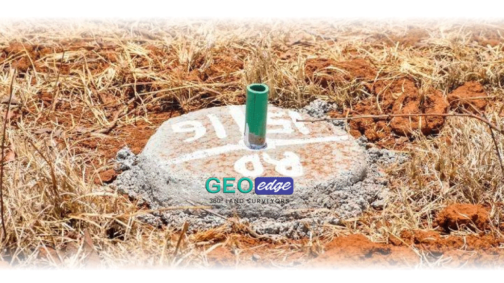
A land beacon is a physical marker used to indicate a surveyed boundary point. Depending on the circumstances, boundary markers may be visible on the ground or may have been disturbed, removed or covered over. A beacon therefore needs to be considered together with the relevant survey records and other boundary evidence.
Why Should You Verify Land Beacons?
Beacon verification can help you avoid expensive mistakes. Imagine constructing a perimeter wall based on an incorrectly identified boundary. You could later discover that the wall crosses into a neighbouring parcel or road reserve. Correcting the problem could mean additional construction costs, delays and a potential dispute.
Verifying your land beacons is one of the simplest ways of gaining confidence about the physical position of your property. Here are some important reasons why you should consider doing it.
1. To Know the True Position of Your Property
A title deed confirms your ownership and provides important information about the registered property, but a landowner also needs to know where that parcel sits physically on the ground. This becomes particularly important when the property is undeveloped and there are no obvious fences, walls or other permanent features.
A professional surveyor can compare the physical situation on the ground with the relevant survey information. The State Department for Lands notes that official land survey searches provide information such as boundary dimensions, beacons, survey numbers and historical changes to the configuration of a parcel.
2. To Avoid Encroaching on Your Neighbour’s Land
You may genuinely believe that your fence is inside your property. Your neighbour may believe the same about theirs. Without professional verification, both parties can work from different assumptions. A survey can help establish the relevant boundary position using survey records and field measurements rather than relying on visual estimates. This is particularly important in areas experiencing rapid development and subdivision.
3. To Detect Possible Encroachment Onto Your Property
Beacon verification is not only about protecting your neighbours. It also protects you. A neighbour’s fence, wall, building, driveway or other development may have crossed into your parcel without you realizing it. This can happen gradually, especially where land has remained undeveloped for many years.
If you suspect that someone has occupied part of your land, do not immediately remove their fence or structure. First establish the boundary professionally. The State Department for Lands recognizes resolution of boundary disputes as a survey-related service involving field inspections, cadastral plans or Registry Index Maps, ownership documents and survey expertise.
4. Because Beacons Can Be Missing or Disturbed
Land beacons are physical markers, and physical markers can be damaged, covered, removed or displaced. Construction, farming, road works, fencing and other activities can interfere with boundary markers. A missing beacon does not mean that you should estimate its location yourself.
The appropriate survey records and other available evidence should be examined before a boundary marker is re-established. Kenya’s Ardhisasa platform specifically recognizes applications by interested persons to ascertain and fix land boundaries where there is uncertainty or a dispute concerning boundaries.
5. To Confirm the Parcel After a Previous Subdivision
Land can change considerably over time. A parcel may have been subdivided several times, resulting in new parcel numbers and boundaries. If you inherited land or purchased a parcel that originated from an older subdivision, it can be useful to understand the survey history connecting the current parcel to the earlier parcel. This is particularly important where old fences, roads and occupation patterns do not appear to correspond with the current survey information.
6. To Protect Yourself During Land Transactions
Boundary verification is particularly useful when selling land. As a seller, you want to avoid a situation where the buyer later claims that the property shown to them does not correspond with the registered parcel. As a buyer, you want to make sure that the land you are paying for is the land you have actually been shown. Survey verification can therefore protect both parties by reducing uncertainty before the transaction is completed
7. To Establish Accurate Coordinates for Your Property
Modern surveying increasingly relies on accurate spatial information. Depending on the type of survey and the records available, a surveyor may establish coordinates for relevant boundary points. These coordinates can be useful for:
- Property identification
- Mapping
- Future surveys
- Construction planning
- GIS applications
- Land management
- Reference during future boundary work
However, landowners should understand that having a GPS coordinate is not the same thing as proving that a particular physical marker is the correct legal boundary point. The coordinates need to be established through appropriate survey procedures and reference to the relevant survey information.
8. To Create a Reliable Record for Future Use
You may not need the survey information today, but circumstances can change. A properly documented survey can become useful when:
- You decide to fence later
- You sell the property
- Your children inherit the property
- You subdivide the land
- A neighbour changes their boundary
- You begin construction
- A boundary dispute develops
Good property records can save future owners considerable time and uncertainty.
9. To Avoid Turning a Small Problem Into a Boundary Dispute
Many boundary disputes begin with a relatively simple issue. A beacon disappears. Someone puts up a fence. Another person assumes the fence is correct. A building is constructed. Years later, the parties discover that their understanding of the boundary is different.
At that point, the issue may become much more difficult and expensive to resolve. The State Department for Lands describes boundary-dispute resolution as involving survey expertise and official land records to establish the location of shared boundaries.
The best time to verify a boundary is usually before there is a dispute.
How Does Land Beacons Verification in Kenya Work?
1. Obtain Your Property Documents
Start with the information you have. This may include:
- Title deed
- Parcel number
- Survey plan
- Mutation
- Deed plan
- Previous survey report
- Beacon certificate or schedule
2. Conduct the Necessary Searches
A surveyor may need to access relevant survey records. The State Department for Lands says a land survey search can provide information including boundary dimensions, beacons, survey numbers and historical changes to a parcel.
3. Inspect Existing Boundary Evidence
The surveyor examines what exists on the ground. This could include:
- Existing beacons
- Boundary walls
- Fences
- Roads
- Neighbouring boundaries
- Other physical evidence
4. Carry Out Survey Measurements
Appropriate surveying equipment is used to establish and verify positions.
5. Compare the Ground Position With Survey Records
This is one of the most important stages. The surveyor is not simply asking: “Where is the beacon?”
They are asking: “Does this beacon correspond with the official survey information and the boundary position?”
Can I Verify My Beacons Using a Phone GPS?
A smartphone can be useful for navigation, but it should not automatically be treated as a survey-grade boundary verification tool. Consumer GPS accuracy can vary significantly depending on the device, satellite visibility and environmental conditions. For a property boundary where accuracy matters, professional surveying equipment and proper survey procedures are more appropriate.
What If the Beacon Is Missing?
Do not guess. Do not simply measure from a neighbour’s fence and put another marker there. A missing beacon may require beacon re-establishment, which involves investigating the relevant survey records and establishing the appropriate position.
What If Your Neighbour Disagrees?
If you and your neighbour disagree about a boundary, avoid moving or destroying boundary markers. Instead, obtain professional survey advice. Where a formal boundary dispute exists, the matter may also require the appropriate legal or administrative process.
When Should You Verify Your Beacons?
Consider doing so:
- Before fencing
- Before construction
- Before buying land
- Before subdivision
- After buying property
- When beacons appear disturbed
- When a neighbour changes their fence
- When parcel dimensions appear inconsistent
- When an encroachment is suspected
Final Thoughts
A few hours spent verifying a boundary can potentially save you from a much bigger problem later.
At GeoEdge Land Surveyors, we help landowners understand the position of their property through professional surveying, measurement, analysis and documentation. If you are unsure whether your land beacons are correctly positioned, contact GeoEdge before fencing or construction begins.

